References
Steel Viaduct Hamburg Barmbek

Project Data
Client
Hamburger Hochbahn AG
Project Period
2025
Project Scope
Digital survey and documentation of the Barmbek steel viaduct as the engineering foundation for the rehabilitation planning of a central Hamburger Hochbahn transit structure dating back to 1912
Scope of Services
Georeferenced photo acquisition during brief scheduled track closures
Setup and incremental development of a digital structural model
Integration of all data into InfraCloud
Providing a collaborative platform for the client and the engineering firm
Structured documentation baseline for rehabilitation measures
——————
Introduction
The Barmbek steel viaduct has been a key transit structure for Hamburger Hochbahn AG since 1912. A conventional surveying approach would have driven up costs and severely disrupted ongoing rail operations – and track closures within Hamburg's dense network are exceptionally hard to come by.
By deploying InfraCloud, Hochbahn succeeded in establishing a robust data foundation under these tight constraints. This allowed future rehabilitation work to be planned efficiently and proactively – without disrupting traffic flow.

Initial Situation
The century-old steel viaduct required a systematic database for rehabilitation planning. However, conventional on-site surveying was virtually unfeasible under the given operational conditions.
Three key challenges defined the starting point: minimal available track closures during active operations, high logistical overhead for traditional surveying, and the lack of a reliable asset data foundation to plan the long-term maintenance of this historic structure.
Our Approach
Georeferenced imagery of the structure was captured during brief, scheduled operational gaps. This image data served as the foundation for building a digital model, which was iteratively developed within InfraCloud to create a high-quality planning baseline.
The cloud-based platform allowed both the client and the engineering firm to collaborate on a single source of truth early in the process – with unified data, clear structures, and highly efficient, aligned workflows.
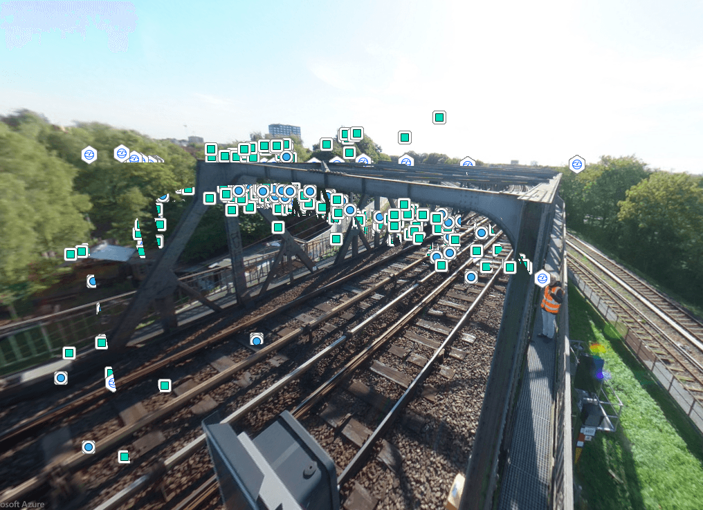
From Physical Structure to Digital Twin
The georeferenced survey data was used to construct a consistent digital model of the steel viaduct. Through InfraCloud, this model was developed into the central working environment for all project stakeholders.
The platform cleanly structures documentation, damage mapping, and structural information, providing a comprehensive digital representation of the 100-plus-year-old viaduct for the first time – forming the base for communication, design, and long-term asset preservation.

The Foundation for Informed Decisions
With InfraCloud, Hochbahn gained an intuitive tool for documentation and collaboration. The digital model delivers a rock-solid, consistent baseline for rehabilitation planning and the long-term preservation of the asset.
By utilizing a shared platform, both the client and the engineering office benefit – coordination effort is minimized, planning certainty goes up, and design changes during the planning phase are drastically reduced.
Impact in Numbers
10% fewer design changes / variation orders
20% reduction in planning costs
Reduced track closure times
Quote
"InfraCloud enabled us to precisely document a century-old structure – providing the ideal baseline for future-proof rehabilitation planning without disrupting ongoing rail traffic." — Lukas Petzoldt, Hamburger Hochbahn AG
Outlook and Next Steps
Hochbahn plans to regularly deploy InfraCloud for existing asset management in the future – particularly for complex or hard-to-access structures. The platform is set to be permanently integrated into strategic maintenance planning.
This integrates digital surveying into a long-term preservation strategy for the city's transit infrastructure – ensuring historic structures are efficiently maintained while keeping active operations running reliably.


