References
Port of Flensburg

Project Data
Client
Flensburger Hafen GmbH
Project Timeline
2023 - 2024 and 2025
Project Scope
Survey of approx. 2 km of quay facilities
Services Rendered
Underwater survey
Photogrammetric survey above the waterline (suprastructure survey)
Terrestrial laser scanning
Creation of a digital twin in the InfraCloud
——————-
Introduction
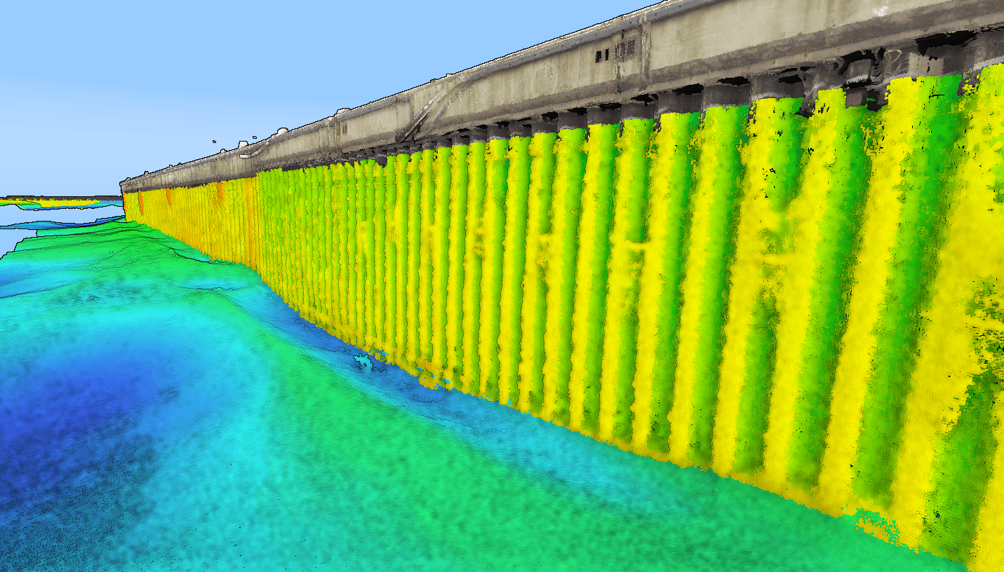
As part of the structural inspection at the Port of Flensburg, the port infrastructure was captured digitally in its entirety for the first time – both above and below water. Using state-of-the-art sensor technology such as HydroScan, HD mapping, photogrammetric methods, and terrestrial laser scanning, we generated a high-fidelity digital replica of all quay facilities. The goal was to establish a solid database for structural health monitoring, allowing future maintenance and retrofits to be planned and documented with higher efficiency. This digital scanning workflow ensures significantly more precise structural condition assessments and supports the sustainable management of the existing port assets.
Initial Situation
The structures to be scanned at the Port of Flensburg comprise a variety of construction types and engineering generations – from quay walls and pile foundations to complex transition zones between the structure and the seabed. A key focus area was the damaged section of the quay wall south of the museum shipyard, which has already been featured in local media by NDR.
The surveying tasks were executed under real-world operating conditions during live port operations with active ship berths. Additionally, winter weather conditions with snow and restricted visibility posed demanding challenges for data acquisition. Despite these constraints, the objective was successfully met: generating a complete, high-resolution as-built record of the port infrastructure.

Our Methodological Approach
To survey the port infrastructure, we deployed a multi-sensor, combined scanning approach to fully capture all key areas both above and below the waterline.
The following technologies were utilized:
Hydrographic survey using multibeam sonar
Underwater scanning using HydroScan technology
Photogrammetric survey of the visible structural elements
Terrestrial laser scanning above the waterline
By combining these methods, even hard-to-reach or visually obstructed areas were precisely documented and integrated into a unified digital model.

From Structure to Digital Twin
The underwater scan using HydroScan, supplemented by the suprastructure survey, allowed for a complete digital mapping of the port facilities. The acquired data was processed into high-density point clouds, detailed 3D models, and further digital datasets that realistically document the current structural state of the assets.
This process yielded the very first consistent, comprehensive view of the Flensburg Port infrastructure – explicitly including the sub-surface zones below the waterline, which previously could only be documented with significant limitations. This dataset now serves as the foundation for digital inspection workflows, structural analysis, and future maintenance planning.
The Foundation for Data-Driven Decisions
The digital as-built survey provides a highly reliable basis for upcoming structural inspections and future engineering workflows. By capturing the damaged areas of the quay wall in high detail, anomalies and structural defects were precisely documented and translated into planning data.
The acquired spatial data enables:
A comprehensive condition assessment of the port infrastructure, both above and below water
Precise analysis of structural damage zones
A reliable data foundation for rehabilitation and maintenance planning
More efficient inspection and documentation workflows
A long-term digital database for future structural health monitoring
Outlook and Future Application
The generated underwater and as-built data serves as the baseline for further root-cause analysis of the structural damage observed along the quay wall. Utilizing these digital models, future technical measures can be systematically planned, modeled, and prioritized.
Furthermore, this asset documentation acts as the reference dataset for the upcoming 2025 structural inspection and for long-term digital twin management of the port infrastructure. Going forward, the continuous utilization of this data enables a modern, predictive, and data-driven maintenance strategy for the Port of Flensburg.


